Nottinghamshire County Councils Community Archaeology will be at Willoughby Deserted Medieval Village to undertake the final section of the topographic survey between Thursday 10th and Saturday 12th May.
The team mapped the northern two fields of the site in 2010, and undertook a geophysical survey a few weeks ago with Peter Masters of Cranfield University.
This final survey will map the southern field where buildings, holloways and an enclosure survive as earthworks as well as medieval ridge and furrow.
Again this session is being run to give people an opportunity to take part in an archaeological method for the Community Archaeology Handbook.
They will be mapping earthwork features for 2D and 3D maps using survey grade GPS, and EDM Total Station (explanation will be given).
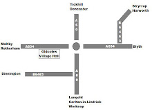
The site is on the side of the road half way between Norwell and Carlton on Trent, and we will be starting at 9.30 am, and working until 16.30-17.00.
Unfortunately there are no facilities on site, and the nearest toilets are in Norwell Churchyard. There is a pub in Norwell.
Please bring adequate footwear, refreshments, suntan cream waterproofs etc.
To apply see www.nottinghamshire.gov.uk/communityarchaeology
The team mapped the northern two fields of the site in 2010, and undertook a geophysical survey a few weeks ago with Peter Masters of Cranfield University.
This final survey will map the southern field where buildings, holloways and an enclosure survive as earthworks as well as medieval ridge and furrow.
Again this session is being run to give people an opportunity to take part in an archaeological method for the Community Archaeology Handbook.
They will be mapping earthwork features for 2D and 3D maps using survey grade GPS, and EDM Total Station (explanation will be given).
The site is on the side of the road half way between Norwell and Carlton on Trent, and we will be starting at 9.30 am, and working until 16.30-17.00.
Unfortunately there are no facilities on site, and the nearest toilets are in Norwell Churchyard. There is a pub in Norwell.
Please bring adequate footwear, refreshments, suntan cream waterproofs etc.
To apply see www.nottinghamshire.gov.uk/communityarchaeology

No comments:
Post a Comment